Where in the U.S. are you most likely to die in a car crash?

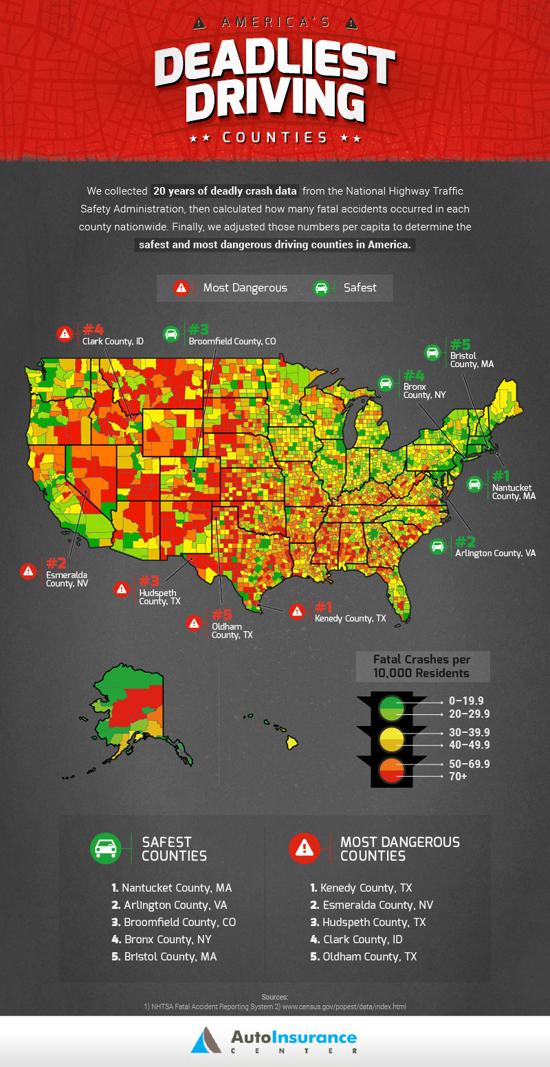
If you've been wondering what the worst-possible road trip locale in America is, you're in luck! The good people at AutoInsuranceCenter.com gathered data from the National Highway Traffic Safety Administration’s Fatality Analysis Reporting System (FARS) in order to figure out the deadliest places in America for car accidents and put together the below graphic. Kenedy County, Texas, takes top honors, and, as Auto Insurance Center puts it, "America’s most dangerous county overall, Kenedy County, is home to just over 400 residents, according the latest census – but 43 fatal crashes have taken place there over the last 20 years, resulting in a staggering per capita rate." The Lone Star State grabbed three of the top five deadliest spots, and all five of the deadliest counties are in western states, whereas the safest counties are concentrated in the east.
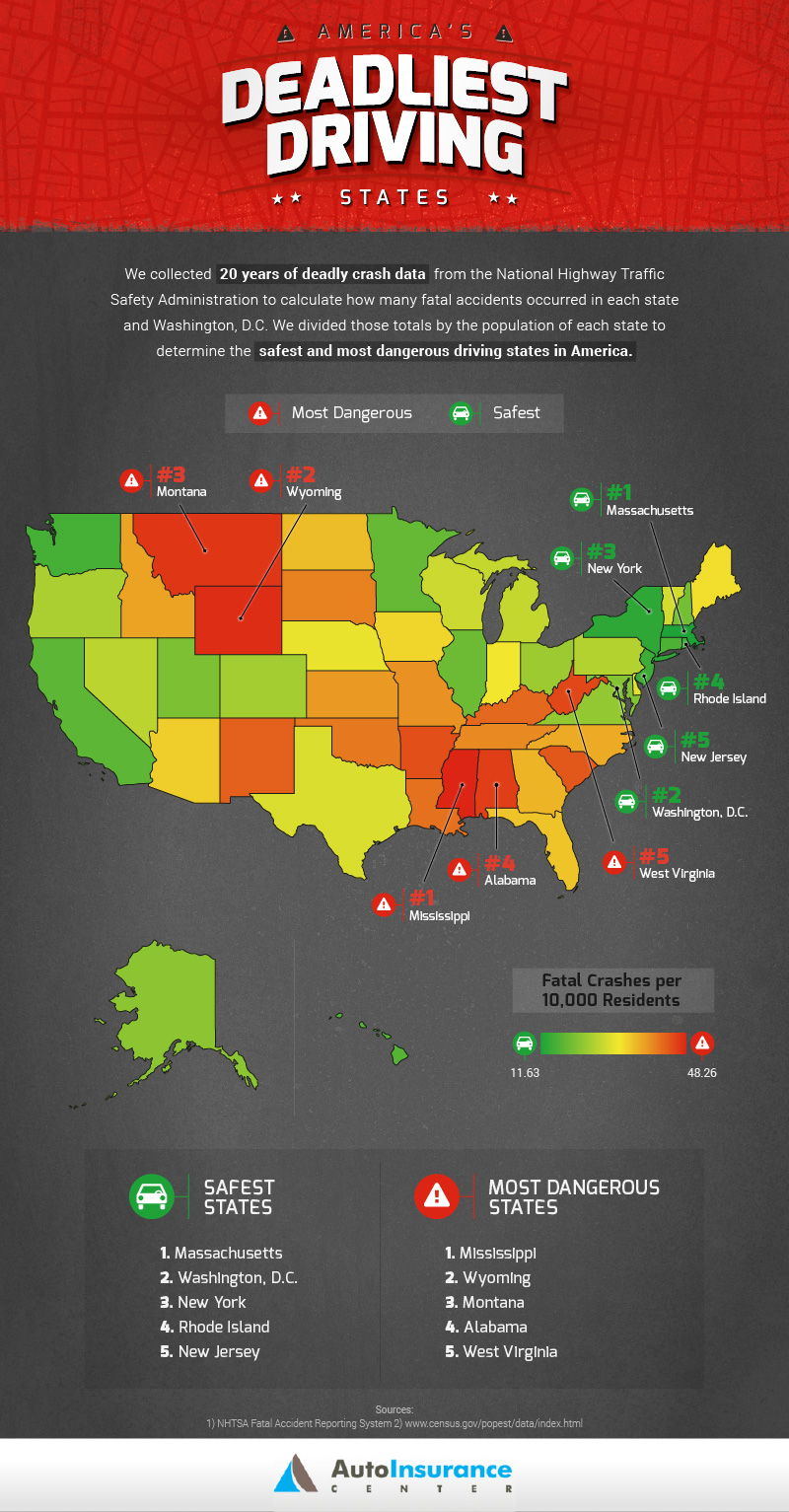
 What's not clear is whether a distinction is made with lower per-capita car ownership. You can take a look at the state-by-state result in the below map, which shows that New England and the mid-Atlantic are best bets for safe driving. The east coast is also much more densly populated than the western states and generally has lower per-capita car ownership. Public transportation is far more available to residents, or people are able to walk to wherever they need go. I wonder how accounting for this would affect the results versus a simple per capita measure. In rural Texas, you need a car, whereas in Boston, it's mostly just an annoyance for which you have to pay $300/month just to leave it in a parking garage. A small town in Montana will simply have a higher percentage of the population driving cars than anywhere in the Bronx. If you adjust for per capita vehicle ownership, which is 5–50% lower in the east and then also present the fatalaties in the context of miles traveled per driver or fatality, then you would be looking at something meaningful. Of course, obtaining those numbers would take a little more work than simply “dividing state auto fatalities by population,” which takes about ten minutes. Of course New York fares well in the DEADLIEST compeition—they have the fourth-lowest cars per capita. Even if you have a car as a city dweller, you're using it for fewer trips and for shorter distances, so these charts could be misleading in that respect. Plus, if you are in an accident in Washington D.C., emergency responders will get to you faster than if you drive off the road at 2 a.m. in Wyoming, so better access to paramedics and hospitals will also push down traffic fatality statistics for cities. Still, you can see how your county and state measure up in the interactive maps available at Auto Insurance Center.

 What's not clear is whether a distinction is made with lower per-capita car ownership. You can take a look at the state-by-state result in the below map, which shows that New England and the mid-Atlantic are best bets for safe driving. The east coast is also much more densly populated than the western states and generally has lower per-capita car ownership. Public transportation is far more available to residents, or people are able to walk to wherever they need go. I wonder how accounting for this would affect the results versus a simple per capita measure. In rural Texas, you need a car, whereas in Boston, it's mostly just an annoyance for which you have to pay $300/month just to leave it in a parking garage. A small town in Montana will simply have a higher percentage of the population driving cars than anywhere in the Bronx. If you adjust for per capita vehicle ownership, which is 5–50% lower in the east and then also present the fatalaties in the context of miles traveled per driver or fatality, then you would be looking at something meaningful. Of course, obtaining those numbers would take a little more work than simply “dividing state auto fatalities by population,” which takes about ten minutes. Of course New York fares well in the DEADLIEST compeition—they have the fourth-lowest cars per capita. Even if you have a car as a city dweller, you're using it for fewer trips and for shorter distances, so these charts could be misleading in that respect. Plus, if you are in an accident in Washington D.C., emergency responders will get to you faster than if you drive off the road at 2 a.m. in Wyoming, so better access to paramedics and hospitals will also push down traffic fatality statistics for cities. Still, you can see how your county and state measure up in the interactive maps available at Auto Insurance Center.


Add new comment